- native MSG format
- out-of-service sats like MSG1
- HIMA9 added
- HIMA: mixed compressed an not compressed (no need to define decomp in HIMA.py)
- Stop processing if needed channels are missing
- search rule of MTI1 adapted
- Besides 'area' (string) geo_images() also accepts struct. sarea from satpy's get_area_def()
this is for resizing for movie frames; sarea contains also new size of image to generate - selection for movie or not (-m commandline parameter), including resizing and adapting subdir for generated files
Notes:
- the MSLP scripts are not supported (yet).
- subdir 'frames' is selected in case of option -m or if the area name ends with '_rss'.
New in 01-05-2024:
-ovl cbgwill add coast, borders and grid.
Usage
./<script>.py [-h] [-t T] [-sat SAT] [-src SRC] [-dst DST] [-o O] [-area AREA] [-composite COMPOSITE] [-m ] [-ovl OL] [-v [V]]
options:
  -h, --help            show this help message and exit
  -t T                  time: YYYYmmDDHHMM
  -sat SAT              satnr: 4, 18, ...
  -src SRC              source dir., MUST be absolute path!
  -b B                  bulk: y|n.
  -dst DST              destination dir.
  -o O                  output file
  -area AREA            area
  -composite COMPOSITE  composite
  -m [M]                reduced size, for movie
  -ovl OVL              overlays: c=coast,  b=borders, g=grid,
                                  r=rivers, l=lakes,   C=cities,
                                  p=points, s=station, L=Legend
                                  A=all, N=none, D or no -ovl: defaults
  -v [V]                Start viewer
| zip file | contains | comment |
|---|---|---|
| satpy_geo_01052024.zip | MSG.py, MTI.py, HIMA.py, GOES.py, GEO_extrastuff.py | added overlay option |
| GEOstuff.zip | GEOstuff.py | MTI format adapted to 'real' MTI see differences orig. file |
LEO scripts
The scripts available in SPStools/LEOscripts are for one area/composite(set) only. You need to copy scripts to another filename for each different area/composite-set you want.
Instead (or also) you can use the scripts described below.
These LEO-scripts are very similar to the original ones, but they contain options for composite, area etc.
So no need to copy/maintain multiple scripts for each satellite.
The LEOstuff.py available here is very similar to the original one, but it contains support for:
- auto-download of TLE's, also for dates in the past
- out-of-service sats like Metop-A.
Usage
./<script>.py [-h] [-t T] [-dn DN] [-sat SAT] [-mp MP] [-histtle] [-src SRC] [-dst DST] [-o O] [-area AREA] [-composite COMPOSITE] [-ovl OVL] [-v [V]]
  -h, --help            show this help message and exit
  -t T                  time: YYYYmmDD
  -dn DN                D|N, D=Day, N=Night
  -sat SAT              A|B|C|X
  -mp [MP]              do multipass
  -histtle [HISTTLE]    get historical tle from spacetrack
  -src SRC              source dir., MUST be absolute path!
  -b B                  bulk: y|n.
  -dst DST              destination dir.
  -o O                  output file
  -area AREA            area
  -composite COMPOSITE  composite
  -ovl OVL              overlays: c=coast,  b=borders, g=grid,
                                  r=rivers, l=lakes,   C=cities,
                                  p=points, s=station, L=Legend
                                  A=all, N=none, D or no -ovl: defaults
  -v [V]                Start viewer
| zip file | contains | comment |
|---|---|---|
| satpy_leo_01052024.zip | MSG.py, MTI.py, HIMA.py, GOES.py, LEO_extrastuff.py | added overlay option |
| LEOstuff.zip | Original LEOstuff but... | Adapted for using spacetrack |
Selector for satpy
Updated 01-05-2024 There are 2 main programs:- satpy_selector.py: select and show/generate using satpy
- satpy_areavis.py: show area's defined in satpy
satpy_selector
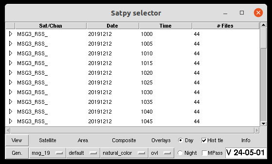
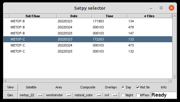
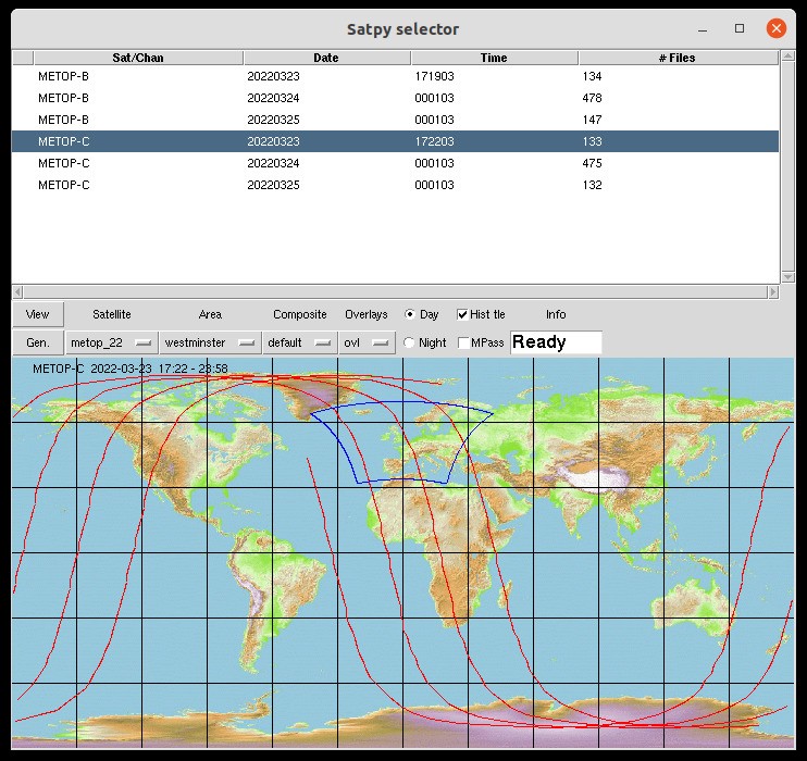
This selector is a simple gui using above scripts (both GEO and LEO) You need also: You must add locations of your raw files into satpy_settings.py. This will create a menu in the selector with all locations. The gui: (geo and leo)
If a polar satellite is choosen and earthmap.gif exists then the track and selected area will be shown:
Now:
- Select type of satellite, this will refresh the list of available data
- Select a line in the list of available data
- for polar sats choose day or night
- choose an area (default=built-in defaults in the used script)
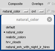
- choose a composite (default=built-in defaults in the used script)
- choose overlay(s): coast, grid etc. (default=built-in defaults in the used script)
- click 'View', will generate an image and open a viewer
- Or click 'Gen', will only generate an image
satpy_settings.py contains 2 lists of satellites including the command to execute them:
- geosattypes
- leosattypes
- exe_cmd=''
- This executes scripts like MSG.py. The scripts must be at a location included in the searchpath and must be executable
- exe_cmd='python <full_path_to_scripts>'
- This executes scripts like python3 /home/user/tools/MSG.py (if <full_path_to_scripts> is /home/user/tools/)
satpy_selector.py uses lists defined in satpy_settings.py:
- data_loc: contains name and location of files. Name may be any name you like; location must be full path. A location normally should contain data of one satellite, but may also contain a mix of different satellites.
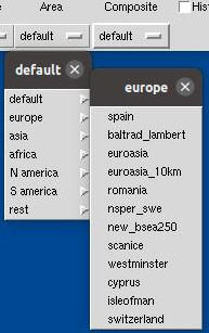
- regio_list: this list contains area's bound by min/max lon and lat.
It is used to divide the very long list of area's, defined in the areas.yaml files, into manageble portions.
You may adapt this list, including names and area def's. The result is used to create a 2-steps menu 'area' in satpy_selector.py:
- composite_list: list of available composites for each satellite. This list, dedicated for each satellite type, may be adapted/extended; not all composites are added yet.
The Composite menu is created/adapted if another satellite is choosen.
- overlay_list: list of available overlays.

Location of files
- The main .py files (MSG.py, Metop.py etc.) are all executable.
You may put them in a location pointed to by searchpath (Linux: $PATH) and then execute them from anywhere like:
- Metop.py -t .......(etc.)
- python3 <path_to_py>/Metop.py -t .....
- Metop.py -t .......(etc.)
- Files used by the main .py files need to be put at the same location:
- GEOstuff.py, LEOstuff.py
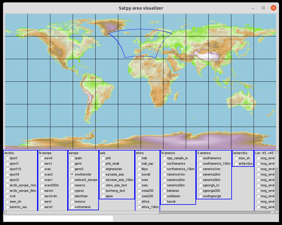
Area visualizer for satpy
(version 2024.01.05, enhanced separation of areas, added scrollbars)
This is a simple gui which shows all satpy-defined area's on an earth map. User-area's are also shown; all areas.yaml files known by satpy are used.
Note: The location of the users-areas.yaml is defined by variable $SATPY_CONFIG_PATH.
Zip-file contains both Python-script and an example earthmap file, but you can use any plate carree map with any size
(width=2x height). No SPStool files are needed, just the satpy installation.
(Note: this is also implemented in the satpy_selector, which shows then both track of selected satellite and selected area.)
Usage:
  -h, --help  show this help message and exit
  -s S        size (multiplier fact.) image (1=org. size)
  -f F        plate carree image file
  -ac AC      colour area
  -m [M]      use menu instead of buttons
Version 20240105:
- Fixed: last item in areas list
- Fixed: empty regio
Problems with tkinter
If your OS is Ubuntu then try this:See also https://realpython.com/python-gui-tkinter