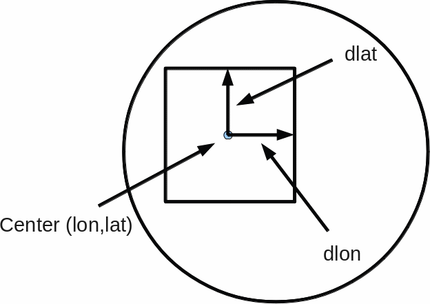
Defining area's in Prefercnces The format is:
area<x>=(name=<name>", clon=<center_lon>, clat=<center_lon>, dlon=<delta_lon>, dlat=<delta_lat>Example:
area1=(name=Europe, clon=6.00, clat=56.00, dlon=19.70, dlat=21.00
area2=(name="Atlantic 2", clon=-18.00, clat=42.00, dlon=19.70, dlat=20.00
area50=(name="North west", clon=-142.00, clat=52.00, dlon=20.00, dlat=20.00
Note:
- Area nr's may contain 'gaps', like in the example where nr. 3 to nr. 49 are not defined.
- Spaces in names are allowed, but the name must then be enclosed between parantheses. See area2 in the example.
From command line, using -area <name>, the name must then also be enclosed between parantheses. - A line starting with '#' is treated as comment and thus ignored.
But note that if in gui preferences is saved this comment line will be lost.
Unexpected behaviour.
A mix of data with different sizes may give sometimes problems. For example, GOES data may cover different parts: full disk, northern part etc. If a mix of this data is selected and then used to export images, then this willl give different results for the different GOES data, of course.But if the Preview button from the 'Files' pop-up is used to zoom in an area covered by all selected GOES items then only the first image will give the expected zoomed area, the others not. Making a movie this way is therefore not possible.
This problem can be solved by defining/using a fixed area covered by all types of images. Now the different GOES data can be used to create images of the same part, or to create a movie. Also if the preview button is used.
Background: preview defines the area relative to the x/y positions of the image, not using actual position.
Defining an area does use actual earth positions, resulting in equally located parts of each source.