For a description of this product see:
KNMI Scatterometer
This KNMI site contains also source files for software to decode the bufr files containing scatterometer data.
I have used them to compile the program Bufr2Asc, which you can download here.
In step 4, at the very bottom of the page, part: Regional Data Service (EUMETSAT Advanced Retransmission Service - EARS):
check: ERS-SCAT
The program
Bufr2Asc is a stand-alone program. You can execute it from a commandline; just 2 arguments are needed:
Bufr2Asc inputfile outputfile
Example input file:
scatt_20080203_101907_ers2___00000_ear_o_250_ovw.l2_bufr
The content of the output file is like this:
#    Lat     Lon      Date  Time   Speed     Dir
   25.02 -109.18  20080202  1752    0.20    4.20
   25.12 -109.66  20080202  1752    0.73  152.00
   24.80 -109.23  20080202  1752    0.20    3.00
Etc.
Speed is in m/sec
Dir:
0=to south
90=to west
180=to north
270=to east
You need to set environment variable BUFR_TABLES to the location where bufr tables are located.
xrit2pic will set BUFR_TABLES and then runs Bufr2Asc. After that the results are plotted in the preview window.
Put downloaded file 'bufr2asc.tgz' into (e.g.) $HOME/bin. (Assuming that you have a search path to this location.)
extract: tar -zxf bufr2asc.tgz
That's all!
The bufr tables will be located in $HOME/bin/bufr_tables.
If you want the bufr tables in another location you need to change the location in preferences of xrit2pic:
Tab Directories, item BUFR Table location'
The following command will be executed by xrit2pic, to translate the bufr file:
The bufr tables will be located in <disk>:\bufr_tables, with <disk> the drive where windows was installed. Normally C:.
If you want the bufr tables in another location you need to change the location in preferences of xrit2pic:
Tab Directories, item BUFR Table location'
The following command will be executed by xrit2pic, to translate the bufr file:
set BUFR_TABLES=c:\bufr_tables/ & Bin2Asc inputfile outputfile
BUFR_TABLES depends of course of the settings in Preferences, tab Directories.
inputfile is the BUFR file, e.g. received via Eumetcast.
outputfile is the result file.
Running.
ERS data is broadcasted via "EUMETSAT Data Channel 1".
That is the same channel as used for NOAA AVHRR.
If you use tqchansel this channel is probably tagged as 'NOAA'.
In Preferences of tqchansel you can see the relation between channel and label on your tqchansel window.
You need to ask Eumetsat to enable ERS-SCAT channel for your EKU.
You can find it on the registration form near:
"Regional Data Service (EARS)".
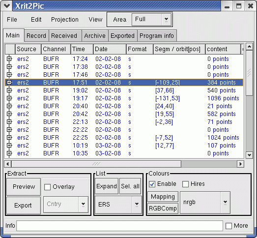
Check in the main window of xrit2pic that you have ERS data vailable:
You can select to only show ERS data, in the 'List' box, see xrit2pic window bottom-middle.
If you select a line the column 'content' should give the amount of measure points;
the column 'Segm / obit[pos] should contain the [lon,lat] position of this measure cell.
If not: Check the 'Info' line at the very bottom of the xrit2pic window. If it contains a line like: Translator 'Bufr2Asc' or bufr tables not found!?
then either program or bufr tables are not installed correctly.
Check in Preferences:
Tab Viewers: Name of bufr extractor: should be Bufr2Asc; check if Bufr2Asc.exe is present in the same directory as xrit2pic.
Tab Directories: Check BUFR Table location, that the directory exist and contains files.
If the content and position info is present then the bufr reader is installed correctly.
Exporting to a file or showing wind vectors on a satellite picture should work.
To preview results on an earth map one more file is necessary: a plate carree picture of the world.
Default setting is a file called 'earthmap.gif'. This low resolution map is present in the
xrit2pic distribution.
You can use any plate carree file for this, e.g. the high resolution files from Blue Marble.
You can change filename in preferences, tab 'Files', box 'Earth maps',
line near 'For scatterometer'.
Next part to rewrite, not clear enough!
Try Export:
Select a ERS-line, and click on 'Export'. You should get a message in the info field, see pic at the bottom.
If you get an error message: Translation failed! then something is wrong with Bufr2Asc installation.
If you get an error message like: ERROR in CheckBufrData: could not find BUFR TABLE B !!! then something is wrong with the bufr table installation.
If you get a message like shown, but mentioning 0 extracted points, then select another ERS item.
If everything is OK you have just translated a BUFR file containing scatterometer data.
This is an ASCII file; you can open it with a texteditor (nedit, wordpad,...) in the destination directory (see Preferences, xrit2pic).
To plot info into a picture you don't need to export the scatterometer data.
Select and make a preview the usual way.
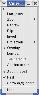
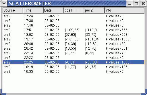
From menu 'View' choose 'Scatterometer'.
This will give you a list of all available ERS bufr files:
Columns 'pos1' and 'pos2' are the positions in [lon,lat] of the first and last data.
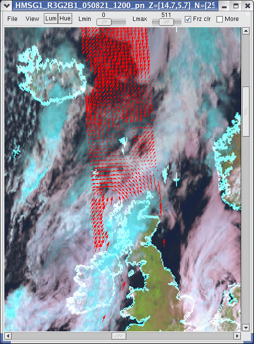
Select one, et voila:
To save the result: File -> Screendump
Note:
The size of an arrow depends on the measured wind strength.
Each bufr file covers a relative small part of the earth. Start with full globe preview, so you know that you will see 'something'.
If you see some red at the horizon then probably you should select another satellite. You can choose any geostationary satellite.
To add in future:
Polar satellites are not supported yet.
There are lots of arrows on a small area. A 'declutter' feature should be added.
Read-out of values should be possible.
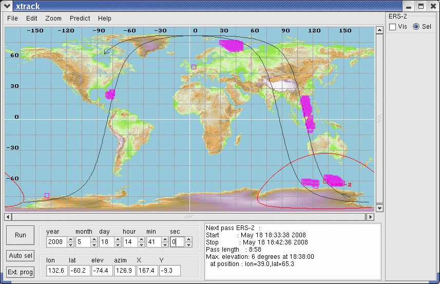
Satellite track ERS2 and collected data.
Starting from drawn ERS-2 location:
start-time
end-time
# data
comment
14:38
14:41
438
near south pole
14:54
15:03
903
the long one near asia
15:17
15:17
0
file received without scattero data: ERS above land
15:40
:41
149
near US
16:10
16:20
129
again near south pole
16:53
16:53
0
file received without scattero data: ERS above land (Russia)
17:07
17:07
0
file received without scattero data: ERS above land (Greenland)
17:47
17:47
0
file received without scattero data though ERS above sea? (near south pole)